
Pair of trails dedicated on Lake Santeetlah

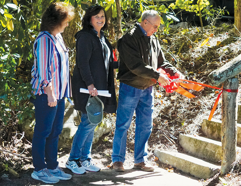
Lake Santeetlah – County Commissioner Dale Wiggins cut the ribbon for a trail re-dedication that he has been working on since 2000.
The Santeetlah Lake Trail South is 8.5 miles long, with Carver Cemetery at one end and the intersection of Snowbird and Santeetlah roads at the other. It passes through scenic woods and follows the lake shore for most of the way. Motorized vehicles are not permitted, but the trail is wide enough for two horses to walk abreast and suitable for off-road bicycles.
It connects with the shorter Santeetlah Lake Trail North Loop.
A re-dedication ceremony was held on Sept. 27 near Carver Cemetery.
The project is a partnership between the U.S. Forest Service and Graham County Travel & Tourism. Wiggins is chairman of the tourism board of directors and in that role, helped form the partnership.
Graham County Travel & Tourism Executive Director Daniel Allison said the trail will provide recreation for local people and tourists, and in so doing, “draw people here and keep people here.”
He said his board was looking for ways to strengthen tourism in Graham County, and that included looking at “underutilized assets.”
One such asset is the south trail. Once a logging road, it was improved for hiking and horseback riding around 2000, but soon fell into disrepair.
Wiggins has been involved in the trail since 2000.
“You can’t say I’m not dedicated to the cause,” he said, describing the route as “nature at its best, everywhere.”
Wiggins resumed his efforts in 2014 with another re-dedication, but it was 2019 when Graham County Travel & Tourism and the U.S. Forest Service started talking about the partnership that culminated in the trail dedication on Sept. 27, despite delays caused by COVID-19.
“The focus is on tourism, but always on the back of my mind is whether local folks can do this, too,” Wiggins said.
It is a win-win for tourists and local residents, he added.
Wiggins will be leaving the travel and tourism board later this year when his term expires as a county commissioner. He said he is not sure what he will do once he leaves the board, but did say that at one time he envisioned an unbroken, 100-mile loop trail from Lake Santeetlah to Tsali Recreation Area.
“Hopefully this is the beginning,” he said.
Wiggins did much of the trail work himself or alongside other workers. He even arranged for new gravel to be poured in the parking area near Carver Cemetery the day before the dedication ceremony. He estimated he spent 600-700 hours on the project in the last year alone.
Getting the trail back into shape involved cutting fallen timber and “hazard trees” along the route, repairing eroded trail bed, repairing culverts, widening the trail and even rebuilding a bridge.
Graham County Travel & Tourism handled contracting and payment for the $55,000 project, while the forest service served as project inspector. Graham County Travel & Tourism will be funding trail maintenance moving forward, with the forest service providing expertise and oversight as well as dealing with any hazard trees.
Graham County Travel & Tourism is working with the U.S. Forest Service on other projects, including improved scenic overlooks along Cherohala Skyway and finding a way to keep Cable Cove Campground open, following a U.S. Forest Service decision to keep it closed.
Old trail, new purpose
Trails have been a thing for decades at the former Civilian Conservation Corps camp off Massey Branch Road.
Trails in and around the camp served CCC workers during the Great Depression era. Years ago, workers – many of them skilled senior citizens – built a paved trail, picnic areas and an overlook to get a better view of the former and now historic camp.
A component has been added to the trail that organizers hope will inspire children to get out in nature and learn about it.
The TRACK Trail at the CCC Camp NCF-24 is a 1/4-mile, out-and-back hike to an observation deck overlooking the old CCC camp, called Camp Santeetlah back in the day.
Along the trail, visitors can use the brochure and read the interpretive signs to discover the history of the CCC NCF-24.
Extend the hike by continuing on the 2.5-mile Cheoah Trail that loops through the forest and connects to the Massey Branch Fitness Trail. You can also access the 0.7-mile fitness trail from another trailhead located on Massey Branch Road.
The Kids in Parks trail (kidsinparks.com) was dedicated by Kids in Parks, GREAT (Graham Revitalization Economic Action Team), the U.S. Forest Service and others who helped along the way, during a ceremony on Sept. 29.
The trail expansion was one of the last projects for Rick Davis when he was director at GREAT.
He helped bring together not only GREAT and the U.S. Forest Service, but Duke Energy, Graham County Travel & Tourism, and the Graham County Community Foundation, among others, to see that the project was successful.
“It’s neat to be part of something bigger,” said Daniel Allison, executive director at Graham County Travel & Tourism.
The link to tourism can’t be ignored. According to Jim Baker of GREAT, tourism in western North Carolina is a $1.3 billion industry, after all. But the benefit for local children was also part of the equation.
GREAT is actively looking for ways to engage young people after school hours and during school breaks, he said, and the TRACK Trail is a great opportunity for local families.
One dignitary at the Sept. 29 dedication was Scooter Brown, ranger-in-charge of the Cheoah Ranger District from 1973-86. Brown had a reputation for getting things done, sometimes waiting for projects to be completed before asking permission from his supervisors.
His office – long since razed – was near the start of today’s TRACK Trail path and near where he raised his two daughters in the quarters that the National Forest Service provided.
While out exploring the area, his daughters, Yvette Carringer and Alicia Parham, found the camp’s name, CCC NCF-24, spelled out in large rocks on the hillside. When the camp was operating, the small valley below was cleared of timber and the rock lettering was clearly visible.
Over the years, trees retook the hillside and the sign was obscured.
Brown thought it would be a good idea to build a hiking trail and overlook where visitors can see the rock sign from one direction and the remains of the CCC camp from the other.
The project took three years to complete and in the end included trails, picnic sites, benches, rock work, kiosks, a split-rail fence, and the overlook. Most of the work was accomplished by older skilled workers from one work program, and younger entry level workers from another program – about 200 in all.
Most of the trail has been refreshed thanks to $50,000 donated for the cause, but the pavement is original to the nearly 40-year-old trail and needs to be repaved.