
Robbinsville – The U.S. Forest Service issued a Jan. 19 response to objection issues raised for the revised Nantahala and Pisgah forest plan.
The response was developed after a review of written objections and virtual resolution meetings with Forest Service officials and objectors, along with further review by an independent team of forest planning specialists.
The new revised plan will replace the current plan, which was created in 1987 and has not been changed significantly since 1994. The new plan is expected to be released by the end of the month.
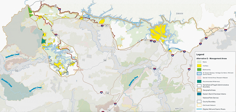
Boards of commissioners in Graham and Cherokee counties were among the objectors to the previous draft plan, called Alternative E, which was a blend of earlier alternatives that combined environmental protections with active recreational use, with compromises added from previous public feedback.
Cherokee and Graham counties do not want additional wilderness areas within their counties. Graham County does not support the designation of Wilderness-Study Areas because “limited access to the forests combined with current management practices literally creates wilderness areas by taking no action.”
While appreciative of past collaboration and the willingness to negotiate less-recommended wilderness areas, Graham County still contends that there is more room for compromise. Cherokee County is concerned that the Unicoi Mountains and Bald River Area are within the boundaries of Cherokee County. They see wilderness designations as too restrictive and a loss to the local economy. They are concerned about loss of access for the motorized communities, recreational tourism and loss of forest products extraction.
The summary of responses included just one example where it seems to be addressing concerns expressed in Cherokee and Graham counties.
That response clarified aspects of management for user-created trails, updated guidance on managing climbing routes through unique habitats, and added management approaches related to visitor management at equestrian campgrounds, all based on input from objectors.
Documentation can be found at fs.usda.gov/goto/nfsnc/nprevision.
Objection process
Objection issues covered nearly every topic of the revision, including the amount of land identified for timber harvest; recommended wilderness and eligible wild and scenic rivers; old-growth management, sustainable recreation, state natural-heritage areas, roads; threatened and endangered species, species of conservation concern protections, invasive species, ecological modeling; and use of best-available, scientific information.
Final instructions and clarifications were shared with the forests’ staff and objectors, following the independent review by the national team. The written responses are the final decision by the U.S. Department of Agriculture on the objections.
The forests complied with all instructions, most of which focused on providing clarifications or additional information.
Here is a summary of changes:
* Wild and Scenic Rivers: Added a newly eligible Wild and Scenic River segment for the North Fork French Broad River, with a recreational classification. Designation as a wild and scenic river is our nation’s strongest form of protection for free-flowing rivers and streams;
* Special Designations: Voluntarily expanded the amount of Special Interest Area management in the Big Ivy/Craggy Mountain and Shope Creek areas, recognizing the ecological, scenic and recreational value of the land. The plan expands the area to more than 12,200 acres overall, an increase of about 800 acres;
* Species protections: Clarified how the plan protects species of conservation concern and the recovery of federally listed species;
* Sustainable Recreation: Clarified aspects of management for user-created trails, updated guidance on managing climbing routes through unique habitats, and added management approaches related to visitor management at equestrian campgrounds, all based on input from objectors;
* Updated process documentation on ecological modeling, species analyses and Wild and Scenic Rivers evaluations.
Given the high volume of issues, as each objection response was finalized, the forest began implementing instructions after the review team completed their work on each issue.
The Nantahala and Pisgah National Forests are part of the Southern Region of the U.S. Forest Service. The region spans 13 states and Puerto Rico. It consists of 14 national forest units and two special units.
National Forests in the Southern Region are managed to strike a balance between resource development and protecting wild places for recreation and wildlife.
The Forest Plan positions the Nantahala and Pisgah national forests to address the challenges that the Forests anticipate in the years ahead, such as the growth of the wildland urban interface; the spread of the insects, disease and invasive species; development pressure on adjacent private lands; unprecedented increase in recreation; and the escalating impacts from climate change.
“In this time of accelerated change, ensuring forest ecosystems are healthy and resilient is critical to long-term sustainability of the diverse habitats these forests provide for wildlife and plants, and for supplying the clean water and other ecosystems benefits that the public depend on,” according to the response. “The forests provide environmental, social, and economic benefits to local and regional communities and across the nation, making the forests an important and unique part of Western North Carolina. The forests make up 27 percent of all forested land in the 18-county plan area and together total approximately 1.04 million acres.
Between ⅔ – ¾ of Graham County is located within the Nantahala National Forest.